- Resilient Durant:
A Multi-Scalar Resilience Framework

Design Resilient Communities
EnD 4970, University of Oklahoma Gibbs College of Architecture, Spring 2026
Monday, Wednesday, & Friday 11:00 - 11:50 AM, Gould Hall 390
Dr. Wei Liu, AICP, CNU-A (Instructor), wliu@ou.edu
Office Hours: Mondays 2 – 3 PM at Gould Hall 245L or remotely by Zoom, request by email
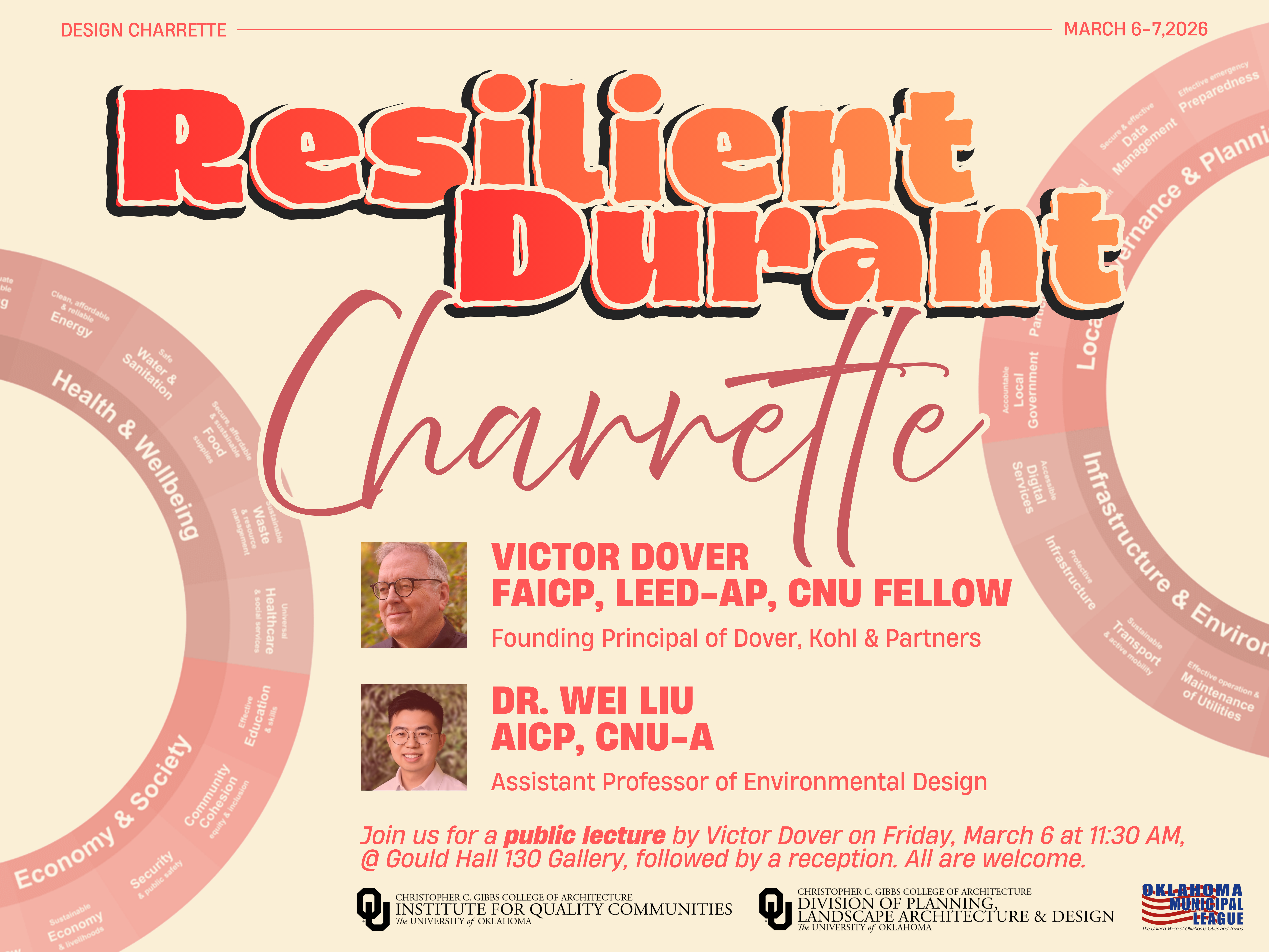
Resilient Durant:
A Multi-Scalar Resilience Framework
Charrette Lead
Victor Dover, FAICP, LEED-AP, CNU Fellow
Founding Principal of Dover, Kohl & Partners
Dr. Wei Liu, AICP, CNU-A
Assistant Professor in Planning, Landscape Architecture & Design
Community Participants
Ryan Brewer, Parks and Facility Manager, City of Durant
Paul Cottrell, Community Development Director, City of Durant
Mike Delloro, Durant Trails and Open Space (DTOS) Board Member
Philip Hightower, Public Works Director, City of Durant
Ryan Jones, Durant Sustainability Coalition (DSC) Board Member
Mark Mesiti-Miller, Durant Sustainability Coalition (DSC) Board Member
Charrette Support Team
Dr. Amber Wiley, Wick Cary Director, Institute for Quality Communities
Molly O’Connor, Program Manager, Institute for Quality Communities
Casey Guest, Administrative Coordinator, Gibbs College of Architecture
Peyton Steger, Graduate Assistant
Monte Dunham, Graduate Assistant
David McPherson, Graduate Assistant, Institute for Quality Communities
Charrette Understanding
The City of Durant, Oklahoma (population approximately 20,000), serves as the county seat of Bryan County and a regional center for education, culture, and economic activity in southeastern Oklahoma. Home to the headquarters of the Choctaw Nation of Oklahoma and Southeastern Oklahoma State University, Durant combines the characteristics of a small rural city with the influence of major institutional partners and growing regional visibility. As the community continues to grow, the city is working to strengthen its economic vitality, public spaces, and infrastructure systems while maintaining its cultural identity and community character.
Like many small and mid-sized communities, Durant faces challenges related to limited municipal capacity, constrained funding sources, and the need to implement long-term planning goals through incremental and strategic investments. The Durant Comprehensive Plan 2040 outlines a vision for a more connected, walkable, economically resilient, and environmentally sustainable community, but progress toward these goals has been uneven due to leadership transitions and resource limitations. At the same time, local nonprofit organizations and engaged residents have demonstrated strong interest in improving walkability, expanding bike and trail networks, enhancing public spaces, and promoting environmental stewardship.
This charrette explores how resilience goals can be translated into design and planning strategies across multiple spatial scales — city and community, neighborhood and district, and block, street, and building. By working across these interconnected scales, the charrette aims to identify practical and measurable approaches that support Durant’s long-term vision for a more connected, inclusive, and resilient community, while recognizing the economic, institutional, and geographic realities of a growing rural city.
Charrette Goals
The City of Durant is working toward a future that is more connected, inclusive, and resilient. This charrette uses the City Resilience Framework to guide planning and design thinking across multiple spatial scales — from city to neighborhood to block-level design.
Goals for this charrette include:
- Strengthen community resilience by translating resilience goals into clear, measurable design and planning strategies across city, neighborhood, and block scales.
- Improve walkability, bikeability, and connectivity between neighborhoods, schools, parks, downtown destinations, and community institutions.
- Support economic vitality and local opportunity through placemaking, improved public environments, and strengthened community infrastructure.
- Enhance public safety, comfort, and accessibility through human-scaled design of streets, public spaces, and everyday environments.
- Promote environmental stewardship and sustainable resource use, including urban tree canopy, green infrastructure, and active transportation networks.
- Encourage collaboration between local government, nonprofit organizations, educational institutions, industry professional, and residents in shaping the future of the community.
Schedule & Program
Friday, March 6, 2026
The Resilience Diagnosis
Goal: Students become experts in the City Resilience Framework (CRF) and establish measurable resilience design parameters for Durant.
| 11:30 AM | Public Lecture |
| Victor Dover, FAICP, LEED-AP, CNU Fellow, Founding Principal of Dover, Kohl & Partners Location: Gould Hall 130 Gallery | |
| 12:30 PM | Reception |
| Location: Gould Hall Living Room | |
| 1:00 PM | Project Brief |
| Introduction to the City of Durant study context, charrette structure, and the City Resilience Framework (CRF), including its four dimensions: 1. Health & Wellbeing 2. Economy & Society 3. Infrastructure & Environment 4. Leadership & Planning | |
| 1:30 PM | Research Challenge #1: The Resilience Audit |
| Students form research teams of three and are assigned two CRF goals. Each team analyzes the City of Durant in relation to those goals across three scales: 1. city/community, 2. neighborhood/district, 3. block/street/building identifying risks, opportunities, and performance gaps. | |
| 3:15 PM | Break |
| 3:30 PM | Research Challenge #2: Resilience Cheat Sheet Development |
| Each team synthesizes its findings into a one-page Resilience Cheat Sheet defining three measurable design parameters that future proposals must satisfy within their assigned goals. For example, the plan must include 30% green space coverage, or the plan must ensure safe routes to schools. | |
| 4:15 PM | Break |
| 4:30 PM | Concept Review & Negotiations |
| Teams present their cheat sheets for collective review. Students evaluate and refine the proposed criteria to ensure they are clear, measurable, realistic, and compatible across resilience dimensions. The outcome is a shared set of resilience performance criteria for Day 2. | |
| 6:00 PM | Wrap-Up Day 1 |
Saturday, March 7, 2026
The Resilient Design
Goal: Students form new teams to synthesize resilience criteria into a cohesive spatial proposal for the City of Durant.
| 1:00 PM | Re-shuffling & Briefing |
| Students reorganize into design teams of approximately eleven members. Each team includes at least one expert from each CRF goal developed on Day 1. | |
| 1:30 PM | Design Challenge #1: The Resilient Design Proposal |
| Design teams produce a resilient design proposal for Durant. Proposals must integrate the Day-1 resilience criteria across resilience dimensions, while working within their designated scale — city/community, neighborhood/district, or block/street/building. | |
| 3:15 PM | Break |
| 3:30 PM | Design Challenge #2: Gap Analysis |
| Stop designing, teams exchange proposals and conduct a peer review using the City Resilience Framework as a checklist to identify missing components, conflicts, or weak integration across resilience goals. For example, “Does this proposal address Goal 5: Sustainable Waste & Resource Management?” or “Does Goal 14: Sustainable Transport & Active Mobility create conflicts across scales?” | |
| 4:15 PM | Break |
| 4:30 PM | Final Presentation & Resilience Matrix |
| Teams deliver presentations explaining how their spatial proposals address all four CRF dimensions. The charrette concludes with a collective synthesis producing a Resilience Matrix for Durant, identifying common strategies, key insights, and future opportunities. | |
| 6:00 PM | Wrap-Up Day 2 |
Research Challenge
Deliverables: Working in teams of three, select two goals from the City Resilience Framework listed below. For each goal, develop clear, measurable design parameters across three spatial scales:
- City and Community
- Neighborhood and District
- Block, Street, and Building
Each team will create a one-page Resilience Cheat Sheet that translates two selected City Resilience Framework goals into three design strategies and measurable performance indicators at three scales: city/community, neighborhood/district, and block/street/building. For example, how a city might support safe and affordable housing through policy and investment, how a neighborhood might strengthen sustainable food access through local systems and services, and how block- or street-level design can improve public safety through the built environment.
City Resilience Framework (4 Dimensions and 22 Goals)
Health & Wellbeing
- Safe, adequate & affordable housing
- Clean, affordable & reliable energy
- Safe water & sanitation
- Secure, affordable & sustainable food supplies
- Sustainable waste & resource management
- Universal healthcare & social services
Economy & Society
- Effective education & skills
- Community cohesion, equity & inclusion
- Security & public safety
- Sustainable economy & livelihoods
- Fair rule of law
Infrastructure & Environment
- Healthy ecosystems, green spaces & biodiversity
- Effective operation & maintenance of utilities
- Sustainable transport & active mobility
- Protective infrastructure
- Accessible digital services
Leadership & Planning
- Accountable local government
- Inclusive civic engagement & participation
- Robust municipal finance & city management
- Secure & effective data management
- Effective emergency preparedness
- Evidence-based planning
Design Challenge
Deliverables: Students will work in three teams, each assigned to one scale (City & Community; Neighborhood & District; or Block, Street, & Building). Each team will develop a resilience-informed design proposal demonstrating how design strategies respond to selected goals from the City Resilience Framework.
All teams should:
- identify priority resilience goals relevant to the study area,
- translate those goals into spatial and/or policy strategies, and
- represent those strategies through diagrams and drawings appropriate to their assigned scale.
The emphasis of this challenge is the translation of resilience goals into actionable spatial ideas, rather than the production of fully resolved design drawings.
Suggested drawing types may include those listed below. Teams are not required to produce all drawing types, but must clearly demonstrate how their design decisions respond to resilience goals.
Scale 1: City & Community Scale
- City Resilience Framework Diagram
- Identification of priority City Resilience Framework goals
- Key citywide challenges and opportunities
- City Structure and Growth Framework
- Community structure diagram (centers, corridors, neighborhoods)
- Growth and development focus area
- Connections between downtown, neighborhoods, and regional systems
- Mobility and Infrastructure Systems
- Major transportation corridors and connections
- Active mobility network (walking and bicycling)
- Infrastructure priorities
- Community Resilience Strategy Diagram
- Public space and environmental systems at the city scale
- Community facilities and services
- Economic activity areas
- Equity and access considerations
Scale 2: Neighborhood & District Scale
- Neighborhood Framework Plan
- Land use framework
- Development intensity strategy (low/medium/high)
- Neighborhood center(s) or activity node(s)
- Mobility and Connectivity Framework
- Street hierarchy
- Pedestrian connectivity
- Bicycle and micromobility routes
- Transit corridor and service routes
- Key intersections and connections to surrounding areas
- Public Space and Green Infrastructure System
- Parks and civic spaces
- Green corridors and landscape connections
- Stormwater and ecological strategies
- Tree canopy and shade strategy
- Public gathering spaces
Scale 3: Block, Street, & Building Scale
- Block Framework Design
- Block size and dimensions (referencing local or historic precedent where appropriate)
- Parcel pattern
- Access pattern (streets, alleys, and pedestrian connections)
- Open space structure
- Street Section
- Travel lanes
- Zones for other modes of transportation (bicycle, micromobility, transit)
- Sidewalks
- Parking
- Street Trees and shade
- Stormwater and drainage strategy
- Public/private edge
- Building Prototype
- Massing
- Shading
- Passive environmental strategies
- Building frontage design
- Ground floor transparency and activation
Charrette Documentation
Each group will collectively document both their design process and final products. Documentation of process and final work must be scanned and submitted to Canvas by Friday, March 13, and will contribute to the course grade.
Participant Requirements
Attendance and Participation
Students enrolled in EN D 4970 Design Resilient Communities and EN D 4993 Environmental Design Capstone are required to attend the public lecture and all charrette sessions for their full duration, and to actively participate in group exercises, discussions, and reviews.
Charrette Materials
The charrette focuses on the rapid development of resilient city design proposals. To support iterative testing, analysis, and refinement over the two-day workshop, work will be completed primarily through analog methods.
Each student should arrive prepared with materials and tools for hand drawing, diagramming, and measuring. Suggested materials include:
- Trace paper
- Engineering scale
- Pens with a variety of line weights
- Markers/rendering pens
- Straightedge
- Post-it notes
These materials are not strictly limited to the list above; students may bring additional tools as needed. Worktables and a limited number of shared tools will be provided.
Charrette Resources
Student Preliminary Research Findings
History of the Place
Basemap Analysis
Socioeconomic Information
Environmental Context
Land Use & Activities
Charrettee References
Durant 2040 Comprehensive Plan
Durant Master Trails Plan 2017
Future Land Use Map
Durant Data Infographics
AARP Walk Audit, Durant, Oklahoma
Durant AARP Livability Index
Bronco Logistics Unlimited Business Plan
Southeastern Oklahoma State University Campus Master Plan
Base Maps
Walking, Jogging and Running Heat Map
Acknowledgment: The structure of this charrette is inspired by a design workshop co-led by Doug Farr, Dr. John Hoal, and Matthew Bernsine at Washington University in St. Louis in 2019, where the instructor served as a faculty assistant.